Monday, June 9, 2014

Bouldering the Rocky Falls of Oriod River

Location: Maranat Falls, Oriod River
Total Distance: 3km of continues boulders, rocks and waterfalls
Total Elevation: 240m
See on Google Map Wikimapia          Click photo to enlarge
What is Bouldering - Bouldering is like sport climbing, but you are climbing on boulders rather than on cliffs and crags. Because the maximum height of a boulder is typically ten feet or so, bouldering is often done without ropes.

Bouldering is a style of climbing emphasizing power, strength, and dynamics. Its focus is on individual moves or short sequences of moves, unlike other forms of climbing, which generally demand more endurance over longer stretches where the difficulty of individual moves is not as great.

To reduce the risk of injury from a fall, climbers rarely go higher than 3-5 meters above the ground. But remember, falling 2-5 meters with no protection at all could be fatal considering you will be landing on solid rocks and boulders. 

One of the major appeals of bouldering is its relatively small equipment requirements, just climbing shoes and a chalk bag or most probably with nothing at all, like I did. 

At least stash dry towel behind your back so you could dry your hands off. Maneuvering up the rock 
walls and search for stable footholds and try to conserve energy.

Sometimes you’d hit a spot where you couldn’t continue, either because it is really a dead end or because it was beyond your ability, then you have to turn back and find another rock.

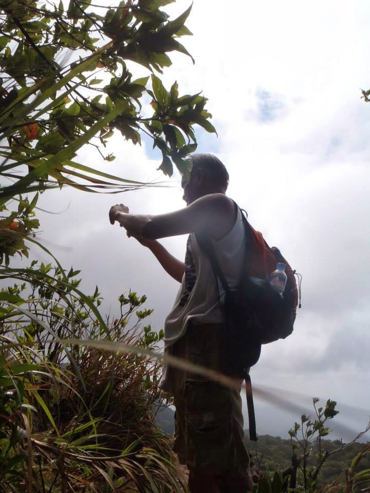
Start of bouldering. This will be your jump off rock.


10 Bouldering Tips and Techniques from outdoorswithdave.com by Mike

1. Picture yourself on a ladder when you climb, move from one hold to the next as 
relaxed as if you were ascending the rungs or steps of a ladder.
2. Avoid over gripping holds with your hands. You will quickly tire your arms out.
3. Use your feet like you would your hands.
4. Trust your feet. You can stand on your legs all day. You don’t hang with your arms 
all day. Too often people hang on their arms and then fall off, sailing right past a monster 
ledge they could have had their feet on.
5. Trust your belayer, and focus on climbing. If you are worried your belayer doesn’t 
have you, find a new belayer you can trust.
6. Concentrate on what is within reach. Sometimes you can use an intermediate hold
(a smaller hold between secure holds) to get to a better hold.
7. Climb from the bottom up, not top down. Of course, if you can see the top of the route,
look to see if there is a pattern working from the goal down to where you are, but when
you start to climb, focus on the climbing at the bottom of the route as you climb up.
8. Climb in an X shape with your hips being the middle of the X. Hang with your arm straight.
Your skeleton can take much more of a load than your muscles can. If the heel of your foot
is hanging too far down you may notice your leg start to shake like a “sewing machine”.
This is very common occurrence, simply apply more weight to your toes so your calf muscle
spasm can stop.
9. Fear of heights is normal. Climbing is all about conquering those fears. Time will cure the
fear of heights. A good trick is to look down no further than your feet to correctly place them
on the best part of the hold.
10. Take your time. Climb like a cat does—quiet, deliberate, and precise. Picture the move,
and then execute it. Use all of your limbs, not just two. The lower the angle of the climb,
the more time you have, so use it. Make each move as fluid as possible.


Now GO, GO, GO....

Your first rock to hurdle. About 5m in height and 45 degree inclination. See video on this rock 


About 30m. (10storey building) high


Balance walk over logs.


My guide....


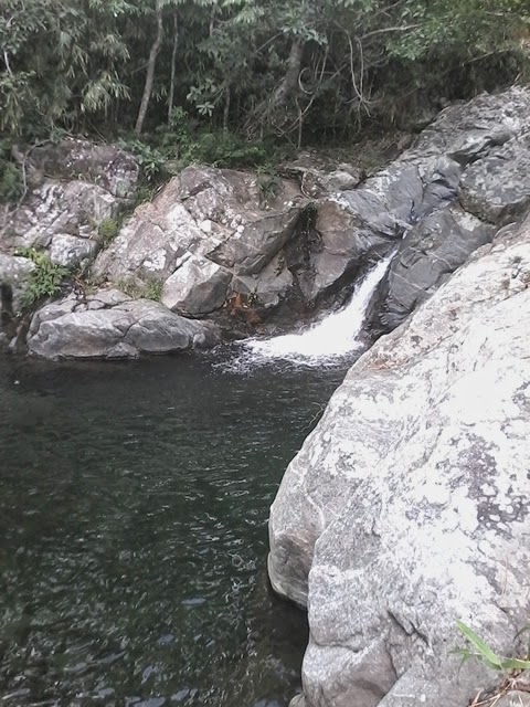
The last water fall in the 3km. stretch. From here you can go back to the jump-off rock 
or turn right to Ka Bisak trail few meters up and hike. 


Related Posts:

Mts. Balagbag, Oriod & Maranat Traverse.


Friday, June 6, 2014

Mts. Balagbag, Oriod & Maranat Traverse.

Locations: Mt. Balagbag is at Bgy San Isidro Montalban Rizal and
                Mt. Oriod is at Bgy. San Lorenzo, Norzagaray, Bulacan

This hike passes the summit of three small mountains easily accessible from manila.
Google map Wikimapia 


A. Jump off - Sitio Licao-licao, Bgy. Macabud, Montalban Rizal.
B. Sitio Balagbag, Bgy. San Isidro, Montalban, Rizal. If you are coming with a car, this is
safe place to park.
C. Start of trail direct to Point K, Maranat Falls river crossing.
D. Summit of Mt. Balagbag, 770masl and registration site.
Note: A to D is 3.8km. (2.4miles) - Ascend 450m
E. End of gravel road - start of trail
F. Left to Ipo River trail.
G. Ipo river crossing.
Note: E to G is 5.7km. (3.6miles) - Descend from 770masl to 540masl = 230m
From point G, you have 2 options:
1. Ascend to Summit 700masl (160m) or
2. Take river hike downstream (westward) to point I or direct to point K.
H. Start of river hike. 2.4km. (1.5miles) from point I
I. House of Ka. Bista. River hike of 2.2km. (1.4miles) downstream.
J. Oriod River crossing.
Note: From point I, ascend to summit 760masl then descend to point J 600masl. 3.0km (1.9miles)
See related post: Rock Climbing and Bouldering the Rocky Falls of Oriod River

K. Maranat Falls (Ipo River crossing)
Note: Point J to K is downstream river hike or maybe more appropriately, bouldering or rock
climbing because the very big rocks and boulders and unending falls along the river.
3.2km. (2.0miles). Descend from 600masl to 340masl (260m).
Ka Nestor Camp Site

About 200m. from the falls is the camp site of Ka. Nestor. The site can accommodate about 40 to 50 tents. Toilet and drinking spring water is available in the camp site.

During my hike I stayed and camped here overnight with the group of Ace Modar of Travel Tipid, swimming in the morning and continued my hike after lunch, back to point C.

Note: Point K to C is 3.8km (2.4miles) ascend from 340masl to 480masl (140m).


Total distance of hike: 22.3km (13.9miles)

Hike and views to the summit of Mt. Balagbag.


Trail photos of descend from Mt. Balagbag to Ipo river (Eastern side).

Portions of the Sierra Madre Mountains


Start of trail. This trail is the route of "Olingeros" or "Charcoal Makers". Supposed
to be illegal but they have no choice. No other source of income is available.
The "Olingero" kids


Trying my strength. I am only good for 1 sack. Not 2, not 3, definitely not 4. I met 1 
"Transporter" carrying 4 sacks. The sharing is 50/50 between the "Transporter" and 
the owner. Transporter can only make 1 trip a day. They negotiate the trail from 4 to 
5hrs. with the load.

The Transport System of "Oling" (Charcoal). Horse or any other means will never be effective 
because of the tough terrain. 


Sample of the trail

Some kids I met along the way. Sisters Maribel, Jonabe and Erlyn. All carrying "Oling" since 8am. I met them about 10:30am and they are only halfway to their destination. They have not eaten daw breakfast yet, so I gave them my baon
of native kakanin.


The "Pugon" where they burn wood to become "Oling".

Part of Ipo river. Very shallow this time of year. Swollen and dangerous during rainy days.


Water source on the trail.


Ka Bisak. I met him in the river trying to fish but got nothing. He invited me to his house for lunch.


House of Ka Bisak where I had lunch. I left my baon lunch with them also and he volunteered
his son to be my guide in the remainder of my hike. 

Kaingin system is still prevalent in the area. Too many trees are cut and burned. Sayang

Now for the downstream bouldering at the Oriod Rocky Falls. See post for this part of the hike
at http://bayanatinto.blogspot.com/2014/06/rock-climbing-bouldering-rocky-falls-of.html
Hikers and swimmers near Maranat Falls. Here I will camp for the night and do my swimming 
the next morning then back to jump off point. 


Mt. Maria Makiling Traverse (MakTrav)

My Hike......

The Myth: 
Maria, the Nymph (airwindzone.wordpress.com)


Mariang Makiling was a young woman. She lived somewhere on the beautiful mountain Makiling, between Laguna province and Tayabas province. No one knew just where or how she lived. Some said she lived in a beautiful palace surrounded by gardens. Others said she lived in a poor hut made of nipa and bamboo. Read more.. Philippine Folklore

Mt. Maria Makiling (As seen from Sitio Jordan) 

The Mountain: 

Location: Los Baños, Laguna
Jump-off: Sitio Jordan, Bgy. Sta Elena, Sto. Tomas, Batangas
Exit: Station 1, UPLB College of Forestry
LLA: 14.13°N 121.20°E, 1090 MASL (Peak 2)
Hours to summit / days required: 1-2 days / 4-5 hours
Specs: Minor climb, Difficulty 4/9, Trail class 3
Features: Tropical forests, variety of flora and fauna

This is Her Majesty, Mt. Maria Makiling, a Heritage Park -  The Mt. Makiling Forest Reserve covers an area of 4,244 hectares, straddling parts of Los Baños and Bay towns and Calamba City in Laguna, and Sto. Tomas town in Batangas province. The others Philippine heritage parks are Mt. Apo Natural Park, Mt. Kitanglad Range Natural Park and Mt. Malindang Range Natural Park, all in Mindanao, and the Mounts Iglit-Baco National Park in Mindoro.

High in biodiversity, the mountain’s odd slopes have sometimes been described as in the slope of a reclining woman.

The Trails:
Sipit Trail

To date, there are 2 recognized trails to reach the summit (Peak 3), The Sipit Trail and the UPLB Trail. These 2 trails meet @ the Summit, Peak 3. The 3rd one, Palanggana Trail (Bgy. San. Bartolome) has been closed by local authorities to hikers due to restrictions from private land owners to which the trails passes. 

1. The Sipit Trail which starts @ the Sto. Tomas Municipal Ecopark, Sitio Jordan, Bgy. San Vicente is the more difficult one. It features roped segments, rocky face, steep ascends, risk, limatik, rattan, tropical rainforest and ridges. The trail consists of 20 stations from jump off (Stn. 1) to Peak 3 (Stn. 20). Required time to Summit (Peak 3) is from 4-5 hrs. 


2. The UPLB Trail which starts at the Forestry Building
UPLB Trail
of the University of the Philippines, Los Banos and ends @ the Summit or Peak 3 passing through Peak 2, the highest point of Mt. Makiling @ 1,090 MASL. This trail consists of 30 stations, easy ascend to the summit which also features roped segments, rocky face, muddy trails, lesser risk, limatik, rattan and tropical rainforest.

The Hikers:


The Hike: 
Route Map
We are taking the MakTrav or Makiling Traverse with entry point at Sto. Tomas Ecopark going North and exiting 
at the UPLB, Forestry Building. The advantage of this North bound traverse (Sto. Tomas, Batangas entry) is that 
at the exit point (UPLB Forestry) you can have a hot shower for FREE. Water source is a natural Hot Spring. 
What more can you ask for after a tumultuous hike.


6:30 AM Meet-up place - 7 Eleven store @ Bgy. San Felix, Sto. Tomas, Batangas. 1 and a half hours bus ride from 
Cubao, Quezon City. 

7 Eleven


------------------------------------------------------------------------------------------------------------
7:00 AM - Arrival at the Municipal Ecopark, Sitio Jordan, Bgy. San Vicente, Sto. Tomas, Batangas. 
10min. tricy ride from 7 Eleven, San Felix. The big pipe in the photo is actually for the 
Mak-ban Geothermal Plant. Power from hot volcanic steam.

Gate of the Ecopark
End of the road
7:05 AM - Registration everyone                                                   
We were 22 in our (Ace Modar) group but according to the entry records
there were more than 200 hikers that day. 20% of that made the MakTrav. 
Young and beauteous hikers. I regret now I am into this at this advance age.
All done
Orientation: The fast hikers on the lead, slower ones, behind


Prayers..."Lord lead the way.. Amen"  Capt. Ace Modar on the foreground


7:30am: Off we go


With the tail group....

Now with main group.....
Now with the lead pack..

The lead group at the rest area....


The rest of the group somewhere behind...


Lead group @ Station 6....


Hikers from U.P. just ahead of me..... This time am alone. the lead group has to wait for the main
group. 

First rope assisted portion...
What lies ahead of the hike...

Where we came from...


Another rope assisted rocky climb... getting harder..
I know ahead of me are two young climbers (husband and wife) I saw at the jump off and they 
left just about 10mins. before us. Hope I could catch up with them.
More ropes.....


Now here he is, right in my nose...

Yes it is them, the young couples...

Couple hikers Sha and Ed Bedural... Now I have company


On Top of the World...
10:30am. At Peak 3. The couples had to go ahead. I need to wait for my group here at the summit (Peak 3)
Heavy fog at the summit...


11:15am.   My Lunch.... After waiting for about 45 mins, I had to move on. I am feeling sleepy already.
Next is Peak 2. about 2 hours hike from here under tall grasses and some trees.


The Mossy forest


Mossy indeed... including myself..

12:30pm.  The summit, Peak 2... No need to rest, need to descend now. My shoes gave up.
Left and right sole. Need to tie them up with a nylon string. 
I was all the way down from Peak 2. After more than 1 hour hike, now i have a glimpse of 
Laguna de Bay.

Now at the Toog trees of UPLB. I am almost there, at the exit but need to ride habal
habal now and find some sleepers. My shoes have totally retired.
2:30pm.. Now at UP Los Banos College of Forestry, Makiling Rainforest Park gate.

How to Get to Mount Makiling via Sitio Jordan:


By public transportation: 

Ride a bus from Cubao or Buendia going to Lucena. Get off at San Felix, Sto Tomas, Batangas (7 Eleven Store. For more convenience, you may rent a tricycle to Sitio Jordan.


By private vehicle: Not advisable for a traverse hike, unless you have driver to bring the car to UPLB from Sitio Jordan